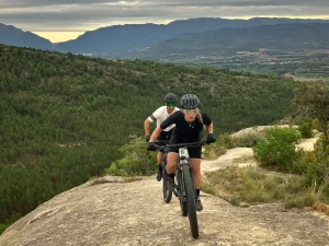
We call Zona dels Nerets the wooded ridge located behind the Sant Antoni reservoir. With a gentle elevation gain and situated very close to Tremp, it is a highly accessible and popular area, especially among local riders during the winter months when the days are shorter.
Most of the trails run through pine and oak forests, with varied terrain that combines fast, flowing sections with technical passages over rock slabs. It is an ideal spot for wet days, as the sandy ground and rock slabs provide excellent drainage, making mud uncommon.
Some of the best-known trails are: MAF, Tamarro, Susterris Views, Búnquer, and Bosquet de la Coma.
The most common way up the ridge is via the track leading to the highest point, though it is also possible to reach it via the technical trail RockandRoll. Other options include ascending from the dam via the old Comportes trail, or climbing via the Búnquer, always paying attention to descending riders. These climbs may require pushing your bike on some sections, especially if you are not used to steep and technical terrain.
We suggest the following route to combine these trails, aiming to avoid repeating the track climb, although it is always possible to link all the trails using the track as the ascent.
Give way to other cyclists and walkers, warn of your arrival in time and slow down.
Do not scare the animals by shouting or making unnecessary noise. You are in their environment.
Take your dog on a leash, especially on the busiest trails.
Respect the signs or fences of private property or hunting grounds.
Follow the established routes, don’t take shortcuts.
Control speed and braking, avoiding skids that erode the ground unnecessarily.
Do not litter.
Avoid clayey areas on muddy days due to rain or fog. Respect the route symbols.
Check your bike before you go out and always carry a repair kit.
Use a helmet, wear gloves, goggles and protection.
Know your physical condition and choose the route based on it. Always evaluate the gradient, not just the distance.
Keep an eye on weather forecasts, they can be changeable.
It is recommended to do the routes with GPS navigation support. The routes are not physically signposted.
It is important to be insured in the practice of mountain biking, which is why we recommend obtaining a federal license or private accident insurance.
The Lo Podall association will not be held responsible for the implicit risks involved in a sporting activity of this type, such as falls, making dangerous descents, misdirection, misuse of common spaces with other activities, etc. Also, it will not be held responsible for the misuse of the routes or for possible imprudences committed by users.